
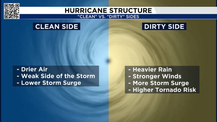
Hurricane Isaias will impact the central Gulf Coast, giving us in Houston a chance to understand an important hurricane concept: the clean side versus the dirty side of a storm.
First, here’s the latest on the storm.
As of Friday morning, Isaias is a Category 2 hurricane with 110-mile-per-hour winds, moving northeast at 14 miles per hour. It’s expected to strengthen into a Category 3 hurricane before making landfall Friday night, somewhere between Gulf Shores, Alabama, and the Florida Panhandle.

I’m going to pause the forecast Friday evening at 5pm. I’ve drawn a line showing the center of circulation.
The dirty side is to the right of the storm’s track. The clean side is to the left.
When you look at the radar futurecast, you can see the difference. The strongest thunderstorms are east of the center, on the dirty side. To the west, there’s much less storm activity.

A hurricane is a giant rotating system. In the Northern Hemisphere, its winds rotate counterclockwise.
When we add the storm’s forward motion, the right-hand side of the storm becomes stronger because the storm’s forward movement and its rotation are working together.
Think of a baseball or softball player taking a swing. The player is the center of the circulation, and the bat represents the rotating winds. When the batter swings toward the ball, the motion of the swing and the motion of the ball are coming together, creating a much bigger impact.
That’s similar to what happens on the right side of a moving hurricane. The forward motion of the storm is adding to the rotational winds, making that side stronger.
On the left side, the forward motion and the rotational winds are working against each other, so the winds are generally weaker.
Think about what happens after the swing. The bat is slowing down, and the batter drops the bat and runs to first base. The forward motion and the rotational motion are no longer working together.
That’s essentially the difference between the dirty side and the clean side of a hurricane: on the dirty side, the storm’s forward motion adds to its rotation. On the clean side, those motions oppose each other.
The heaviest rain is expected on the dirty side, with parts of the Florida Panhandle and southeastern Georgia potentially seeing 6 to 10 inches of rain. Meanwhile, Mobile, Alabama, could see considerably less.

If the storm makes landfall near Pensacola, the highest surge, potentially 6 to 9 feet, would be to the east of the center.

The strongest winds will be near the eye, but the greatest wind threat also extends to the right of the storm’s track. And remember, tropical-storm-force winds are strong enough to bring down trees and cause power outages.

Finally, there’s the tornado threat. That’s also greatest on the dirty side, where the atmosphere is more favorable for tornado development.
Why? As a hurricane moves over land, the friction from the ground changes the wind flow, creating spin in the atmosphere. That spin can help produce tornadoes.

So, here’s the takeaway: The right side of a hurricane’s track is generally where you’ll find the greatest threats from flooding, storm surge, damaging winds and tornadoes. That’s the dirty side.
The left side is typically the weaker, less intense side.
And now you know why, even within the same hurricane, the impacts can be dramatically different depending on where you are. You never want to be on the dirty side of a hurricane.


